A small volcano near the Philippines capital erupted on Sunday, shutting down the main international airport and prompting the evacuation of tens of thousands.
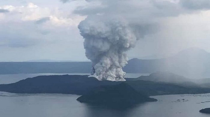
Taal volcano, one of the most active volcanoes in the country has been continuously blasting a column of steam, ash, and pebbles up to 9 miles into the sky as far as the capital on Sunday.
The Philippine Institute of Volcanology and Seismology raised the alert status to “Level 4,” which means that a “hazardous explosive eruption” was expected within hours to days. The highest alert is set at Level 5, reserved for ongoing magma eruption. The agency also warned that surrounding areas were at risk of a volcanic tsunami.
Tens of thousands are expected to evacuate from nearby cities and towns. Authorities scrambled to evacuate more than 6,000 villagers from an island in the middle of a lake, where the volcano lies. About 300,000 people from nearby coastal towns were targeted to be moved to safety overnight and in the next few days. The Philippine Red Cross deployed thousands of volunteers and at least nine ambulances in three surrounding provinces.
Officials said the volcano tremors began around 11 a.m. local time and were followed by two volcanic earthquakes with magnitudes of 2.5 and 3.9, which were felt in Tagaytay City and Alitagtag.
Tens of thousands are expected to evacuate from nearby cities and towns. The Philippine Red Cross deployed thousands of volunteers and at least nine ambulances in three surrounding provinces.
Taal consists of multiple stratovolcanoes with its primary three-mile-wide Volcano Island, which has 47 craters and sits in a lake. The volcano has 33 recorded eruptions, the latest of which was in 1977.
The Philippines lies along the Pacific’s “Ring of Fire,” a 25,000-mile horseshoe-shaped ring, accounting for approximately 90 percent of the world’s earthquakes.
The region contains 452 volcanoes, more than 75 percent of the world’s active and dormant volcanoes. It is also located under Earth’s subduction zones, where oceanic plates slide under the lighter continental plates. Earthquakes tend to happen when those plates scrape or subside underneath each other, and when that happens at sea it can spawn tsunamis.